Keeha Beach/Cape Beale Trail
Location: West coast of Vancouver Island, Canada
Date: May, 2010
Duration/ total length: Two days/ 16 kilometres
STORY AND PHOTOS BY DUSTIN WALKER
Every couple of hundred metres, we had to stop, look around and figure out where the trail had gone. If you could even call it a trail.
Amid the layers of collapsed trees, overgrown ferns and tangled vines, Brad and I could just make out the red flagging tape flapping against distant branches. We really had to watch for it. That often meant keeping our eyes on faraway trees rather than the terrain in front of us.
Pools of knee-deep mud and slippery roots hid underneath a floor of shrubs and giant leaves. I stumbled, slipped and tripped as we slogged through the muck. Yet, we considered ourselves lucky: the skies were blue and we were relatively dry. At least for now.
***

This is actually part of the Cape Beale Trail, not a random shot of the bushes.
On paper, these treks look a cinch. Keeha Beach is a measly three kilometres from the trailhead, while the trek to the Cape Beale Lighthouse is only six kilometres. But challenges soon pop up once you’re actually hiking along these little-known routes.The way is clogged with deadfall trees stacked above long stretches of mud. At some spots, the Cape Beale Trail seems to disappear entirely. Hikers must pay close attention to the flagging tape in the trees or else risk wandering deep into the woods.
This trek is known as one of the muddiest on Vancouver Island, so it gets few trekkers outside July and August. But those willing to slog through the muck and climb through the brush will be rewarded with pristine beaches, starfish-covered caves and a trip to Vancouver Island’s first lighthouse.
Clear skies and unseasonably warm weather greeted my friend Brad and I for our late-May trek. However, almost a week of rain had left this trail soggy and slick. After a couple of kilometres, we reached a fork in the trail. We veered to the left and headed to Keeha Beach, where we would camp for the night. Then we’d backtrack the next day and take the opposite route, which leads to Tapaltos Beach and the Cape Beale Lighthouse.

The mud continues.
Little sunlight filtered through the thick forest canopy, leaving the Keeha Beach Trail swollen with mud. It dragged down our legs and made hauling the packs much more difficult. After a steep trek up a moss-covered hill, we emerged at the beach. Smooth sand formed a half-moon stretching several kilometres. Giant chunks of drift wood lay scattered up and down the beach, which previous hikers had built swings and box-shaped structures out of. Someone had even scrawled ‘Keeha Bar and Grill’ on a chunk of wood and strung it up near a wall of twisted logs.

One of the structures built with driftwood at Keeha Beach.
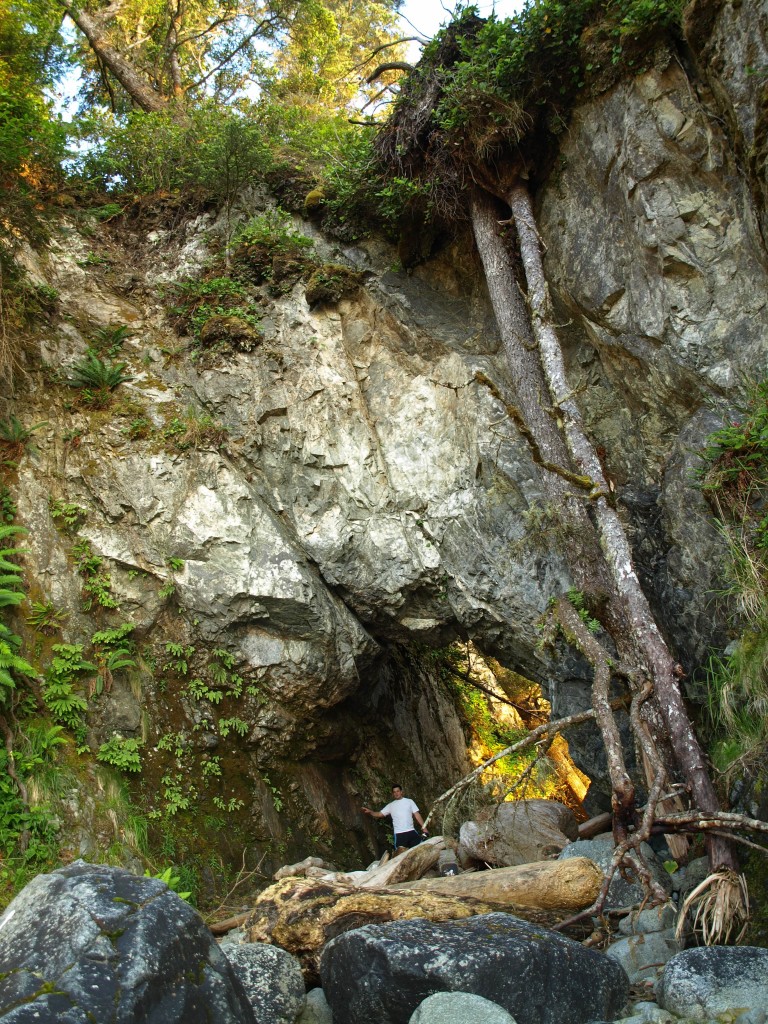
Past this driftwood shanty town, we discovered a rocky cave covered in purple and bright-orange starfish. After climbing along the rugged shore, and admiring sea urchins, cucumbers and other creatures in the tide pools, we returned to camp. Only one other group – a large family – slept on the massive beach that night.
In the morning, we backtracked to the fork in the trail and hid our packs deep in the brush. The thick vegetation made it an easy task. We thought shedding about 40 pounds of gear each would make the 10-kilometre round-trip easy. We were wrong. More deadfall covered this route, forcing us at times to balance along slippery logs. We often lost track of the flagging-tape-marked trail as we pushed through the bush. A thick fog welcomed us when we finally arrived at Tapaltos Beach. The mist added an eerie quality to the area, especially when we neared a wrecked fishing boat that sagged against the shore.
It took us half an hour to find where the next stretch of trail began. Finally, we located a moss-covered buoy at the edge of the forest and began trekking through
the trees once again. This path was almost completely overgrown. We summited a steep hill and then, just as the fog faded, made our way to the mud flats. This area is passable only at low tide and can fill with water quickly. We had only about two hours to spare, so we jogged across the flats and up a steep trail to the Cape Beale Lighthouse. After a quick chat with the lighthouse keepers, and an even quicker glance at the open-ocean landscape, we scurried back down toward the main trail again. More slipping and fumbling; more mud and bushwhacking until we were finally back at the truck.
The Keeha Beach/Cape Beale Trails are perfect for trekkers wanting to explore a technical route while avoiding the crowds. Expect to be rack up some bruises as you stumble and slide along the muddy paths.
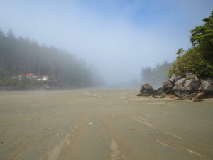
The mud flats hikers must cross before arriving at the Cape Beale Lighthouse.
Getting there:
The Cape Beale and Keeha Beach Trails are located near Bamfield, about 200 kilometres northwest of the City of Victoria on Vancouver Island, Canada. To reach Bamfield, you must first drive a 76-kilometre gravel logging road that begins near Port Alberni. The trailhead for the treks is located at the end of Imperial Eagle Road, northwest of Bamfield. There is some parking available about 50 metres from the start of the trails.
Do you prefer the trails less travelled?
Join like-minded trekkers by signing up for the S&TT e-mail list. Every week, you’ll get:
- Profiles of little-known hiking destinations
- Gear reviews for backpackers and hikers
- Feature articles on strange and off-beat hiking
Plus we’re 100% spam-free (and proud of it)