DISTANCE (round-trip)
22.3 mi (35.88km)
DIFFICULTY
TIME
3-4 days
ALTERNATIVE TO
Art Loeb Trail
SOLITUDE
Extreme Topography in the Blue Ridge Mountains
The Blue Ridge Mountains in North Carolina are some of the most beautiful mountains in the world. Western North Carolina features some incredible hiking, and I’m not just talking about Smoky Mountain National Park. This entire region is made up of endless ridgelines, its forests carpet the mighty peaks and the trails wind among ancient trees.
So called the Blue Mountains because of a bluish haze that forms in the atmosphere. Transpiration is happening on such a massive scale that the forests are exhaling enough gasses to actually bend the blue light in the atmosphere. Not only is the forest all encompassing but it is the most bio-diverse deciduous forest on the planet.
The river inside the gorge drops a spectacular 2,000 feet winding through the wilderness. Linville Falls mark the beginning of the canyon and its ancient course has etched out a primeval rock formation. Inside the canyon, groves of virgin forests remain, saved from the lumber mills by the impenetrable valley walls.
Linville Gorge Wilderness area is a stunning canyon located in Pisgah National Forest. Her steep rocky walls make hiking into and out of the gorge an experience. Appalachian hiking is no joke, the trail climbs and descends over 5,000 feet throughout the duration of the hike.
There are no switchbacks, steep climbing with some upper body strength is required. Unlike many other Eastern hikes, because of the steep rocky cliffs, there are plenty of views. Hardcore hikers and masochists will enjoy this intense backcountry trek.
When to go
Spring and Fall are the best time to go. Free permits are required from May 1 through October 31 because Summer is much busier. Try hiking it in the winter, when there is no snow.
Getting there
Located an hour and 14 minutes north of Asheville. Take 240E out of town, merging onto 40 East for about 41 miles. Take 126 North to the Wolf Pit Trailhead
Know before you go
- This is not an easy trail. There are extreme inclines and declines, 22 miles will feel like 44 miles.
- There are copperheads and rattlesnakes, look before you step and watch where you place your hands.
- Hunters are prevalent in the fall, wear orange to not get shot.
For more information:
- Great article that can help plan your trip!
- Hiking in the Smokies also has some fantastic information on this area in general.
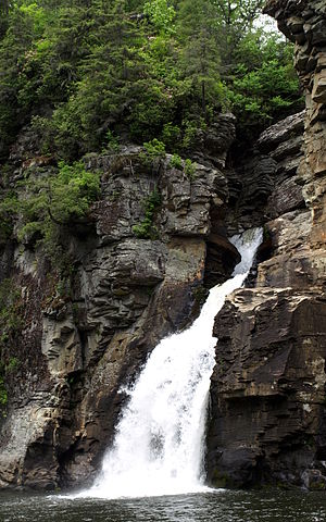
The north end of the canyon. Photo credit: Ken Thomas
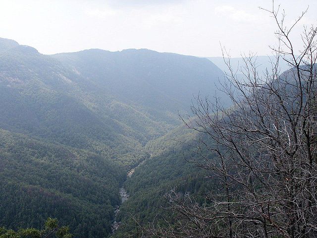
View from Wiseman's View. Photo Credit: Wikipedia Commons
Gear Recommendations for this trail: