DISTANCE (round-trip)
331 mi (533km)
DIFFICULTY
TIME
20-30 days
ALTERNATIVE TO
The Arizona Trail
SOLITUDE
An unknown trail
through unmarked territory
The Grand Enchantment Trail is still relatively unknown and only the most serious thru-hikers attempt it. At over 770 miles long, the western half of the sendero is in Arizona, the Eastern portion in New Mexico.
Beginning on the outskirts of the Phoenix Metropolitan area and ending in Albuquerque, this hike encapsulates the landscape of the American Southwest. The Arizona section begins in the Superstition Mountains and traverses some of the most remote areas of the State.
The trail follows rare riparian habitat, offering not only the best opportunity for wildlife sightings but also water.The Sonoran Desert is the most biologically diverse desert on the planet, the emblematic Saguaro cactus can be seen here by the thousands.
The trail also traverses “sky islands”, mountain ranges so tall the peaks collect rain and offer perennial water sources. Isolated from other water sources by the lower elevation desert, plants and animals in the sky islands are extremely unique.
Unmarked and still relatively unhiked, the Arizona section of the Grand Enchantment Trail beckons the boldest of hikers.
When to go
Begin the hike in Arizona during the spring, March-early April, this time of year boasts lower desert temperatures and melting snow creates water sources. If attempting the entire trail, hike West to East, leaving the high terrain of New Mexico for the warmest months.
Getting there
One hour From Phoenix, take 202E, continue onto 88E, making a right onto N1st water rd. The trailhead will be at the end of the road, 2.6 miles up.
Know before you go
- The Grand Enchantment Trail itself is not marked and using maps is not only recommended but necessary for full completion.
- Protect yourself from sun exposure, wear a hat and sunscreen every day.
- Always plan your next water source, especially when leaving the mountains.

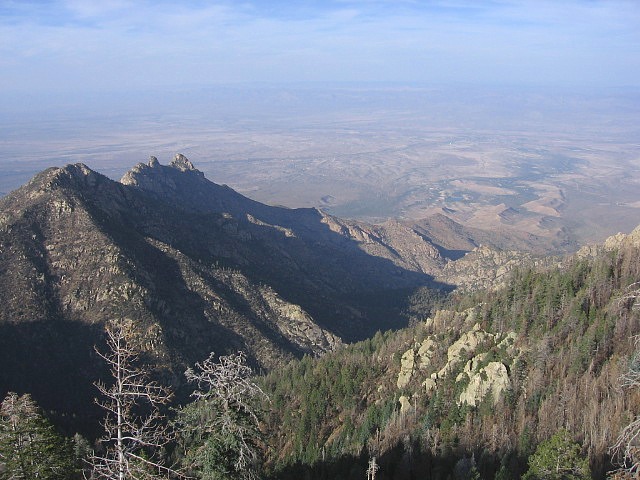
Taken by Brett Tucker, Simblissity.
Gear Recommendations for this trail:
- The Ultimate Sun Hat (a must-have on this trail)
For more information:
- Everything you need to plan your own hike can be found here: Simblissity Trail maps, guides and more.